Where Does Up North Actually Start? An Ecologist, a Highway Map, and Michigan’s Great Divide
Somewhere on every drive north, somebody says “now we’re Up North,” and the argument starts. We ranked the four classic lines, checked them against where the white pines take over and picked a winner.
- Published
- Read
- 9 min
- Comments
- Be the first to comment
In this story
Every Friday between Memorial Day and Labor Day, somewhere between the Zilwaukee Bridge and Grayling, someone in a loaded Subaru or a Silverado hauling an aluminum Lund turns to the passenger seat and says it:
“Well, now we’re Up North.”
And almost immediately, an argument breaks out.
If you grew up in Oakland County, Up North is wherever the subdivisions yield to strip malls with bait coolers — maybe Birch Run, maybe Clare. If you grew up in Grand Rapids, you don’t even look up from your podcast until U.S. 131 narrows past Big Rapids or crests the hill into Cadillac. If you live year-round in Petoskey or Charlevoix, you consider anything south of M-72 to be northern Indiana. And if you’re a Yooper leaning over the bar in St. Ignace, the entire Lower Peninsula is just one sprawling downstate suburb populated by trolls who wouldn’t know a hemlock from an ornamental crabapple.
Local TV stations from Detroit (WDIV) to Cadillac (9&10 News) rerun this debate every spring like clockwork. They run viewer polls, quote a few drivers at a gas station and shrug their shoulders: It’s an attitude, not a line.
They’re wrong.
Unlike most Michigan cabin arguments — who makes the best pasty, whether Vernors cures pneumonia or whether euchre reneging warrants banishment — this one has an objective, scientific answer.
Nature drew the line centuries before the Department of Transportation paved Interstate 75.
The Line on the Forest Floor: The Tension Zone
If you want the real border, you don’t ask a chamber of commerce or a TV poll. You ask a botanist.
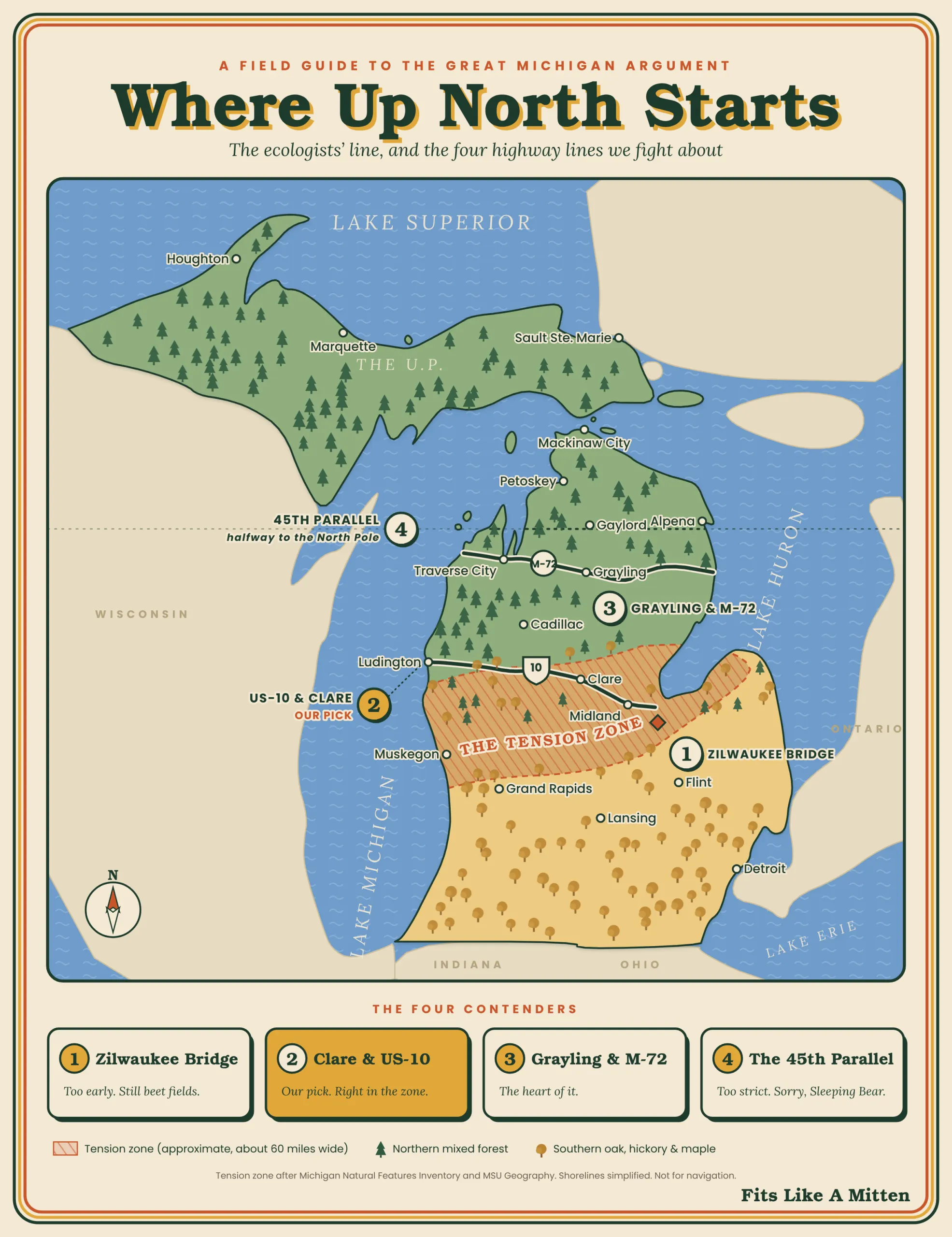
Michigan is cleaved in two by a biological boundary known to plant ecologists as the floristic tension zone. It’s not a straight surveyor’s parallel like the 45th. It’s a wavy transition belt roughly 60 miles (about 95 kilometers) wide that runs across the middle of the mitten, roughly along a line from Muskegon to Bay City.
The Michigan Natural Features Inventory (MNFI), which classifies the state’s natural communities, takes this line seriously enough to put it in its official glossary. Look up “northern” and you get one line: “Occurring north of the climatic tension zone.” The state’s ecologists settled the argument years ago. They just didn’t tell the rest of us.
South of the tension zone, upland forests run to oak and hickory, or beech and maple: white oak, black walnut, bitternut hickory, sassafras and tulip trees rooted in heavier, loamier soils.
North of the line, the soil shifts to coarse, acidic sand that holds less water, and the winters get longer and snowier. The southern hardwoods thin out, and the woods turn to mixed forest, where hardwoods and conifers grow together: balsam fir, white spruce, jack pine, black spruce bogs, trembling aspen, tamarack and the king of them all — Pinus strobus, the Eastern white pine.
When MNFI lead ecologist Joshua Cohen went on Michigan Public’s “On Hand” to talk about where the north begins, he pointed to the science of natural communities. But even for a professional ecologist, it comes down to something you can see from the highway: Cohen said the Eastern white pine is his own personal cue that he has arrived Up North.
Animals notice the line too. It’s roughly where box turtle country ends and wood turtle country begins. MNFI places Eastern box turtles historically in the southern and western Lower Peninsula, while wood turtles occur primarily in the northern Lower Peninsula and the U.P. It’s where the soil changes from warm brown loam to pale sand topped with an inch of needles, and where the air first picks up that sharp, resiny draft of sweet fern and balsam after a rain.
If you want an ecological definition of Up North: It’s the line where the white pines take over.
The Four Highway Contenders: A Driver’s Taxonomy
Of course, nobody checks soil pH while cruising at 78 miles per hour with two kayaks strapped to the roof. We measure our escape by mile markers, gas stops and neon signs.
Across decades of highway travel and local arguments, four traditional cultural borders have emerged:
1. The Zilwaukee Bridge (I-75) / North of Grand Rapids (US-131)
The Gateway of Wishful Thinking.
- The Argument: For downstate suburbanites escaping Friday rush hour out of Detroit or Ann Arbor, cresting the steep arc of the “Z-Bridge” over the Saginaw River feels like crossing the Rubicon. The factories of Flint and Saginaw are in the rearview. You see water and sky. It’s also the most popular answer: in WDIV’s 2022 poll of more than 1,400 readers, the Zilwaukee Bridge won with 34.8%.
- The Verdict: Too early. You’re still surrounded by sugar beet fields and oak woodlots. The Zilwaukee is psychological release, not geography. You’re still in the thumb’s orbit.
2. Clare and US-10
The Traditionalist’s Line.
- The Argument: Clare has long been called the “Gateway to the North,” and there’s a “Where the North Begins” billboard on U.S. 10 to back it up (even if White Cloud makes a competing claim over on M-37). It’s where U.S. 127 funnels traffic up from Lansing and Mount Pleasant; it’s where generations of drivers have pulled off for a fritter and black coffee at Cops & Doughnuts. Just north of town, the southern farm fields yield to rolling sand plains, and jack pines close in on the road shoulders.
- The Verdict: The cultural winner. Clare sits right in the thick of the ecological tension zone. Cross U.S. 10 and it always feels like the car thermometer drops a couple of degrees, the cell signal starts getting choosy and the cheese and beef jerky billboards start lining up.
3. Grayling and M-72
The Purist’s Line.
- The Argument: Ask someone who lives in Traverse City, Petoskey or Alpena, and they’ll tell you Clare is practically Ohio. For year-round northern Lower Peninsula residents, the true north doesn’t begin until the high sand plateau of Crawford County. Grayling is Au Sable River country, the scent of cedar smoke, the Camp Grayling artillery rumbles in the distance, and the junction where M-72 cuts coast-to-coast from Empire to Harrisville.
- The Verdict: The Heart of It. If Clare is the threshold, Grayling is the interior room. By the time you reach Hartwick Pines, home to Lower Michigan’s largest remaining stand of old-growth white pine, you’re undeniably in the northern woods.
4. The 45th Parallel
The Cartographer’s Line.
- The Argument: On U.S. 131 north of Mancelona, or right at Atlanta on M-33, roadside signs mark the line: halfway between the equator and the North Pole. It’s clean, it’s indisputable on a globe and it runs right through Old Mission Peninsula, Leelanau and Gaylord.
- The Verdict: Too strict. If Up North starts at the 45th, then Sleeping Bear Dunes, Manistee, Ludington and Houghton Lake are “south.” Try telling someone watching the sunset from the top of the Pierce Stocking overlook that they aren’t Up North yet. You’ll be laughed off the dune.
The Golden Rule of Cabin Geography
The polls never agree, and it’s easy to see why. Detroit’s WDIV readers picked the Zilwaukee Bridge. 9&10 News, broadcasting from Cadillac, drew its line at U.S. 10. Ask long enough and you start to notice a pattern:
Up North is always at least one county north of wherever you happen to be standing.
To a Detroiter stuck in construction on Interstate 696, it’s Clare. To someone in Clare, it’s Roscommon. To a resident of Traverse City fighting downtown bumper-to-bumper traffic in July, it’s Cross Village or the Upper Peninsula. And to a resident of Marquette, the entire Lower Peninsula is a mythical land of six-lane expressways and strip malls somewhere below the bridge.
The Insider’s Test: The Five Senses
Forget the map for a minute. If you grew up with a cabin key on your keychain, you don’t need a GPS coordinate. You know you’ve arrived through your senses:
- The Sound: The pavement rhythm changes. That rhythmic concrete slap of downstate expressways gives way to the hum of asphalt patched after brutal freeze-thaw cycles. Then you roll the window down and hear the wind through trembling aspens — a sound like dry rain.
- The Smell: Sweet fern crushed in the ditch under hot summer tires, cedar swamp dampness at dusk and woodsmoke from a barrel sauna.
- The Light: Up North light is different. Once you clear the humidity and city haze, the sky over Lake Michigan or Huron turns a crisp, saturated cobalt that washes out into pale apricot around 9:45 p.m. in late June.
- The Commerce: You pass the last suburban big-box grocery. From here on out, groceries come from Family Fare, an independent village market, or a roadside farm stand with a coffee can for an honor box. Hardware stores sell nightcrawlers and snowmobile belts next to the milk.
- The Speed: Tailgating stops being an aggressive maneuver and becomes an invitation to wave someone past on a two-lane stretch of M-37.
The Verdict
So where does Up North start?
If you want the truth that satisfies both the poet and the scientist, point your bumper toward U.S. 10. You’re in good company: it’s the same line 9&10 News drew.
When you cross that invisible line between Midland and Clare, or between Ludington and Reed City, you cross out of the southern farm belt and enter the glacial sand country. The oaks step back. The white pines step forward. The air cools. The tension leaves your shoulders.
You aren’t just north. You’re home.
The first Fits Like A Mitten tees are on the way. Join the list to hear the day the founding drop opens.

Pass it along
Send this digital postcard to a friend.
We’ll email them the card, your note and a link to the story. No stamp needed, and nobody gets added to a list.


Comments